

What's Included
Historical Materials
For the first three years of project development (2009-12), our focus was on the North Carolina portion of the Parkway (approximately half of the Parkway, which threads through seventeen North Carolina counties). In 2012, we began adding materials related to the Virginia portion of the Parkway. "Driving Through Time" now brings together for the first time a vast array of primary source materials documenting the Blue Ridge Parkway’s history from the 1930s to the present:
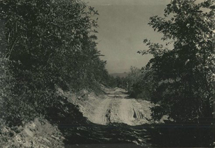
Typical Country Road in Western North Carolina, 1936
Photograph by A. S. Burns
Courtesy National Park Service, Blue Ridge Parkway
- Thousands of historic photographs from the collections of the Blue Ridge Parkway-National Park Service and the North Carolina State Archives.
- Hundreds of historic maps and drawings from the Blue Ridge Parkway and the North Carolina State Archives, including the Parkway Land Use Maps (depicting the as-built condition of the Parkway), the Parkway Land Acquisition Maps (showing parcels of private lands purchased by the State of North Carolina for the Parkway), and several maps showing alternate Parkway routings considered in 1934.
- Letters and documents from the University of North Carolina Libraries pertaining to the history of the Little Switzerland community on the Parkway.
- Historic photographs from UNC’s Hugh Morton Collection depicting the history of the Parkway at Grandfather Mountain, NC.
- Oral histories with key individuals, from the collections of the Blue Ridge Parkway/National Park Service.
- Selected historic photographs, documents, postcards, maps and other materials about the Parkway from the University of North Carolina Library’s North Carolina Collection.

Special Features
In addition to making Parkway materials from several different archives available and searchable online, "Driving Through Time" includes two features that organize the materials in space as well as in time:
- To the extent possible, each item included in the collection has been assigned a geographic coordinate, linking the historical document to the Parkway location to which it pertains. This allows many of the collection’s items to be found via the geo-browse function that identifies clusters of items relating to specific locations.
- Additionally, many of the historic maps have been georeferenced, or aligned with their proper location on the present-day landscape, a technique the permits users to "see through" historic maps, compare past and present, and visualize how the Parkway might have looked had alternate plans been carried out. These maps are also available for download in a format suitable for use in Geographic Information System (GIS) software. Please visit the Davis Library GIS page for more information.
To provide context for the materials, "Driving Through Time" has a growing set of interpretive “overlooks” – short essays or exhibits that allow visitors to peer into the past and glimpse some dramatic episodes in the Parkway’s history.
Finally, "Driving Through Time" also includes a robust set of materials suggesting ways for teachers to use the collection’s primary source materials in K-12 classrooms.


