
Driving Through Time - The Digital Blue Ridge Parkway

Search Results:
-
 Near Balsam Gap, Plott Balsam Range: Waterrock and Jones Mountain
August 14, 1935
-
 Mayapple Gap - Doubletop Mountain
August 11, 1936
-
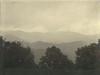 Mountains toward the south
August 11, 1936
-
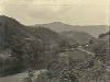 Tuckaseegee River Valley
August 12, 1936
-
 Panorama of Proposed Parkway at Point North of Webster
August 13, 1936
-
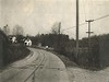
 Approach to curve
November 16, 1940
-
 Curve from reverse direction
November 16, 1940
-
 Approach to curve
November 16, 1940
-
 Approach to curve
November 16, 1940
-
 Approach to curve
November 16, 1940
Items in Query
Results: 61
Refine Your Search
Types (3)
Photographs (53) Newspaper Articles (5) Maps (3)Locations (5)
Milepost 430 (38) Waynesville (11) Section 2W (8) Milepost 442 (3) Milepost 439 (1)Sections (1)
2W (61)Counties (1)
Haywood (61)

