
Driving Through Time - The Digital Blue Ridge Parkway

Search Results:
-
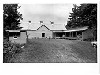
 Sandwich Shop (now Visitor Center)
1950s
-
 Apple Barn #208
1950s
-
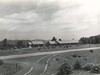
 NC-80 overpass at Buck Creek Gap
1950s
-
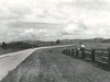 Parkway
1950
-
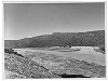 Parking Overlook
1950s
-
 Scenic View - from Parkway (N.C.) - Looking north into Virginia (distance)
1950
-
 Bluffs Coffee Shop & Gas Station
1950s
-
 Wildcat Rocks
1950
-
 Craggy Dome
1950s
-
 Residence, Bluffs Bldg# 35
1950s
Items in Query
Results: 120
Refine Your Search
Types (4)
Photographs (112) Maps (3) Newspaper Articles (3) Drawings, Plans, and Projections (2)Locations (52)
Doughton Park (15) Milepost 125 (10) Mabry Mill (Va.) (7) Bluffs Coffee Shop (6) Dixie Caverns (5) Bluffs (4) Hanging Rock (4) Moses H. Cone Memorial Park (4) Wildcat Rocks Overlook (4) Fox Hunters Paradise (3) Soco Gap (3) Bass Lake (2) Bluffs Lodge (2) Chestoa View Parking Area (2) Craggy Dome Parking Overlook (2) Flat Rock Overlook (2) Flat Top Manor (2) Grandfather Mountain (2) Milepost 217 (2) Milepost 272 (2) Salem (Va.) (2) Afton Overlook (1) Alligator Back (1) Asheville (1) Bent Mountain (1) Buck Creek Gap (1) Craggy Dome (1) Craggy Gardens Visitor Center (1) Craggy Picnic Area (1) Intersection of Blue Ridge Parkway at U.S. Route 221 (near Blue Ridge, Va.) (1) Laurel Springs (1) Mahogany Rock (1) Milepost 164 (1) Milepost 235 (1) Milepost 239 (1) Milepost 247 (1) Milepost 248 (1) Milepost 265 (1) Milepost 286 (1) Milepost 375 (1) Milepost 6 (1) Mount Mitchell (1) Rocky Knob (Va.) (1) Section 2A (1) Section 2C (1) Section 2D (1) Section 2J (1) Section 2W (1) Section 2X (1) Sugarloaf Mountain (1) Undetermined (1) Waterrock Knob (1)Sections (25)
2C (35) 1N (12) 2G (8) 1T (7) 2A (6) 2P (6) 2D (3) 2E (3) 2J (3) 2Y (3) 1M (2) 2B (2) 2H (2) 2K (2) 2X (2) 1B (1) 1C (1) 1L (1) 1R (1) 1S (1) 2F (1) 2M (1) 2N (1) 2R (1) 2W (1)Counties (15)
Alleghany (42) Roanoke (23) Watauga (9) Floyd (8) Avery (7) Buncombe (7) Haywood (4) Wilkes (4) Ashe (3) Jackson (2) Yancey (2) Augusta (1) Botetourt (1) Nelson (1) Patrick (1)

