
Driving Through Time - The Digital Blue Ridge Parkway

Search Results:
-
 Moses H. Cone photo
December 1908
-
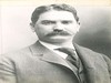 Moses H. Cone
1880s
-
 Virgil US #60
-
Parkway Land Use Map Section 2-F
-
 Deep Gap Panorama
Items in Query
Results: 495
Refine Your Search
Types (5)
Photographs (474) Maps (11) Drawings, Plans, and Projections (4) Newspaper Articles (4) Oral Histories (2)Locations (37)
Flat Top Manor (114) Moses H. Cone Memorial Park (82) Section 2G (44) Julian Price Memorial Park (34) Milepost 276 (24) Milepost 285 (24) Blowing Rock (20) Section 2F (20) Milepost 294 (16) Bass Lake (15) Milepost 292 (14) Milepost 296 (14) Milepost 274 (10) Green Mountain Bridge (7) Sandy Flat (7) Milepost 290 (6) Intersection of Blue Ridge Parkway at U.S. Route 221 (near Blowing Rock, N.C.) (5) Aho Station (4) Milepost 293 (4) Flat Top Mountain (N.C.) (3) Holloway Mountain Road (3) Bamboo Gap (2) Milepost 283 (2) Milepost 286 (2) Milepost 288 (2) Milepost 295 (2) Milepost 297 (2) Raven Rock Overlook (2) Sumter Cabin Creek Road (2) Watauga County (2) Boone (N.C.) (1) Goshen Creek Viaduct (1) Milepost 275 (1) Milepost 279 (1) Milepost 289 (1) Price Lake (1) Sims Pond (1)Sections (4)
2G (340) 2F (96) 2E (35) 2H (24)Counties (1)
Watauga (495)

