
Driving Through Time - The Digital Blue Ridge Parkway

Search Results:
-
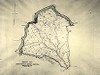 Typical Sheet Property Map
20th Century
-
Regional Sketch Map
1935
-
Location Plan for Overpass at North Carolina St. H'way #26
1935
-
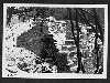
 Early Construction
August 24, 1936
-
 View of Rattle Snake Mountain looking north. Parkway in lower right-hand portion of picture
October 21, 1936
-
 Bridge Construction
December 1, 1936
-
Qualla and 3200 Acre Tracts, Cherokee Indian Reservation, North Carolina
1937
-
L.F. Caudill
1938
-
Land Acquisition Maps Section 2-A
1938
-
 Picnic Shelter
March 28, 1938
Items in Query
Results: 52
Refine Your Search
Types (3)
Maps (39) Photographs (10) Drawings, Plans, and Projections (3)Locations (31)
Bluff Park (7) Cumberland Knob (4) Section 2G (4) Section 2A (3) Section 2B (2) Section 2N (2) Section 2R (2) Bluff Park Maintenance Area (1) Bluffs (1) Cumberland Knob Park (1) Doughton Park (1) Laurel Springs (1) Milepost 238 (1) Milepost 239 (1) Milepost 254 (1) Mount Mitchell (1) NC State Line (1) Section 2F (1) Section 2J (1) Section 2K (1) Section 2L (1) Section 2M (1) Section 2P (1) Section 2Q (1) Section 2U (1) Section 2W (1) Section 2X (1) Section 2Y (1) Section 2Z (1) Undetermined (1) Virginia State Line (1)Sections (20)
2C (12) 2A (9) 2G (4) 2N (3) 2B (2) 2D (2) 2R (2) 1W (1) 2F (1) 2J (1) 2K (1) 2L (1) 2M (1) 2P (1) 2Q (1) 2U (1) 2W (1) 2X (1) 2Y (1) 2Z (1)Counties (14)
Alleghany (22) Watauga (5) Buncombe (4) Yancey (4) Jackson (2) McDowell (2) Ashe (1) Avery (1) Cherokee (1) Grayson (1) Haywood (1) Surry (1) Transylvania (1) Wilkes (1)

