
Driving Through Time - The Digital Blue Ridge Parkway

Search Results:
-
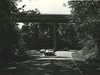 Bridge
1960s
-
 Signs
Signs
1960s
-
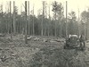 Lumbering
1960s
-
 Karl Synder, Seasonal Interpreter (died 12/12/73)
1960s
-
 Balsam Gap Sign
1960s
-
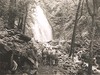 Crabtree Falls Nature Walk
1960s
-
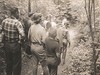
 Tourists and Scenic Overlook
1960s
-
 Crabtree Falls Nature Walk
1960s
-
 Overlook Shelter, Bldg#89, Built by ERA in 1938
1960s
-
 Signs
Signs
1960s
Items in Query
Results: 100
Refine Your Search
Types (1)
Photographs (100)Locations (40)
Sharp Top Mountain (Va.) (10) Peaks of Otter (8) Devil's Courthouse (7) Peaks of Otter Lodge (Va.) (6) Craggy Gardens (5) Julian Price Memorial Park (4) Mabry Mill (Va.) (4) Mount Mitchell (4) Crabtree Meadows (3) Craggy Gardens Visitor Center (3) Milepost 86 (3) Section 2Y (3) Balsam Gap (2) Flat Rock Overlook (2) Milepost 285 (2) Milepost 388 (2) Milepost 425 (2) Milepost 56 (2) Peaks of Otter Campground (2) Peaks of Otter Picnic Area (2) Peaks of Otter Visitor Center (2) Raven Rock Overlook (2) Undetermined (2) Waterrock Knob (2) Cumberland Knob (1) Cumberland Knob Park (1) Gillespie Gap (1) Jackson County (1) Milepost 139 (1) Milepost 271 (1) Milepost 375 (1) Milepost 390 (1) Milepost 393 (1) Milepost 448 (1) Milepost 59 (1) Milepost 97 (1) Milepost 99 (1) Montvale Overlook (1) Pinnacle Gap (1) Roanoke, Va. (1)Sections (19)
1K (35) 2P (10) 2V (9) 2X (5) 1T (4) 2F (4) 2G (4) 2N (4) 2R (4) 1G (3) 2M (3) 2Y (3) 2A (2) 2J (2) 1L (1) 1P (1) 2E (1) 2L (1) 2Z (1)Counties (16)
Bedford (36) Buncombe (14) Jackson (9) Watauga (8) Transylvania (7) Floyd (4) McDowell (4) Yancey (4) Amherst (3) Avery (2) Haywood (2) Alleghany (1) Franklin (1) Roanoke (1) Surry (1) Wilkes (1)

