
Driving Through Time - The Digital Blue Ridge Parkway

Search Results:
-
Parkway and Local Road Relocation
1948
-
Sign Types and Locations
1948
-
Land Acquisition Maps Section 2-Q
1948
-
 Culvert construction. Masked inlet to prevent circulation of cold air.
January 9, 1948
-
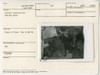
 Culvlert construction. Concrete mixing setup.
January 9, 1948
-
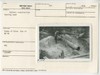 Culvert construction. Heating sand.
January 9, 1948
-
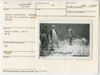
 Culvert construction - Concrete mixing crew and runway to top slab
January 9, 1948
-
 Culvert construction heating water
January 9, 1948
-
 Culvert construction. Covering top slab for protection against weather.
January 9, 1948
-
![Culvert const. [construction] top slab completed.](https://docsouth.unc.edu/loris/blueridgeparkway/misc/0087_p_otter_mp_86.jp2/full/100,75/0/default.jpg) Culvert const. [construction] top slab completed.
Culvert const. [construction] top slab completed.
January 9, 1948
Items in Query
Results: 82
Refine Your Search
Types (3)
Photographs (78) Maps (3) Newspaper Articles (1)Locations (23)
Virginia State Route 43 at Little Stony Creek (15) Moses H. Cone Memorial Park (8) Sharp Top Mountain (Va.) (8) Milepost 238 (7) Peaks of Otter Bus Station and Camp Store (6) Flat Top Manor (5) Intersection of Blue Ridge Parkway at Virginia State Route 679 (4) Peaks of Otter (4) Milepost 87 (3) Bluff Park (2) Milepost 86 (2) Section 2F (2) Section 2Q (2) Bluffs (1) Intersection of Blue Ridge Parkway at Virginia State Route 43 (1) Milepost 0 (1) Milepost 292 (1) Milepost 293 (1) Milepost 79 (1) NC State Line (1) Rockfish Gap Overpass (1) Swannanoa Gate (1) Virginia State Line (1)Sections (11)
1K (39) 2G (14) 2C (10) 1N (4) 1B (3) 2F (2) 2Q (2) 1J (1) 1W (1) 2A (1) 2H (1)Counties (8)
Bedford (40) Watauga (17) Alleghany (11) Roanoke (4) Augusta (2) Buncombe (2) Grayson (1) Nelson (1)

