Going to the Show: Lesson Plans
Explore evolution of personal transportation in Wilmington, North Carolina in the early 1900s through the use of images, Sanborn Maps and Wilmington City Directories
Introduction | Activity 1 -4 | Activity 5 - 7 | Worksheet (pdf) | Learn More
Activity 1: Analyzing the first images: 15 minutes (as a class):
Provide students with a photo-analysis worksheet, or a questionnaire you have developed that includes the basic questions you want to cover.
Have students take five minutes to look at the following photos, and ask them what aspects they note, from a transportation perspective. They can look at things like people, vehicles, road conditions, intersections. See if they can infer what time of year it is. What would have been the passenger experience in these vehicles have been like? How is parking handled? What types of dangers and hazards might be associated with this type of travel? Have them start thinking about consequential side-effects of this type of transportation (e.g. cleaning up horse manure in the city streets). Ask students questions about what types of supporting services and businesses would be built around this type of transportation.
Have them spontaneously jot down their impressions as they are viewing the photographs to capture their first impressions.
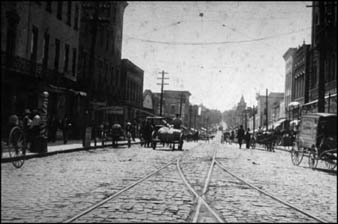
Wilmington: Front Street between Princess and Market looking south - last century (late 1800s)
http://wwwtmpapps.nhcgov.com/lib/history/fales/pages/slides/618.htm
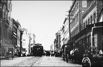
Front Street, looking north before motor cars
http://wwwtmpapps.nhcgov.com/lib/history/fales/pages/slides/762.htm
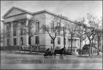
City Hall on 3rd Street: 1900 (see Dray):
http://wwwtmpapps.nhcgov.com/lib/history/fales/pages/slides/26.htm
After students have had a few minutes to look at the photographs, have them read the following news clipping:
Wilmington Star (8/30/1907)
MESSENGER BOY INJURED
Ran Over on Bicycle by Prancing Horse on Front Street Yesterday
http://docsouth.unc.edu/gtts/content/341/
Clyde King, a Western Union messenger boy, was run over and severely injured on Front Street nearly in front of the Y. M. C. A., yesterday afternoon about 5 0'clock by a fractious horse being ridden by a negro. The messenger boy was riding up the street and the horse became frightened at a passing car, pitching the boy on his bicycle. The negro was thrown of face foremost and also injured to some extent buy young King suffered worst, receiving a bad scalp wound and a bad contusion on the leg. He was picked up by persons passing and carried into the drug store of the J. Hicks Bunting Company, where he received attention by Dr. Jos Akerman. Later he was sent to his home at 121 South Eighth street. The wheel of the lad was broken all to pieces. The negro rider of the horse is said to be blameless in the accident as the horse was clearly beyond his control and he himself was thrown with considerable violence to the paved street.
After the students have had a few minutes to look at the pictures, spend 10 minutes to record their impressions using either the photo analysis worksheet or the questions noted above.
Activity 2: Exploring and Analyzing the 1904 Sanborn Map: 20-30 minutes (demonstration, as a class):
The next part of the class will explore Sanborn Maps available within the UNC DocSouth Going to the Show digital collection. These maps provide a unique geographic view of the city, its buildings and infrastructure. The Going to the Show website offers a variety of maps across several points in time, allowing viewers to explore how these cities evolved over time.
Use this lesson as an introduction and orientation for the students to acquaint them with the Sanborn Maps, the user interface features and navigation methods.
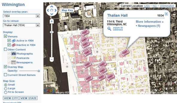
For this lesson, you will focus on buildings near the Wilmington City Hall, which can be quickly and easily located by finding Thalian Hall, which is co-located with the city hall building, and remains in operation today.
Provide students with the Evolution of Travel Worksheet so that they can record initial their initial findings as you work through Activities 2 and 3. Explain that this worksheet will provide a summary of the horse-based and automobile-based businesses that you identify during your explorations.
If students have individual computer access, have them follow along as you go through the following steps:
- Open a browser and go to the Going to the Show website: http://docsouth.unc.edu/gtts/
- In the city: pulldown, select Wilmington, and then select [GO] This will take you to the primary interface to explore the city of Wilmington. You will see that the Sanborn Map for 1915 has been overlayed onto a Google Map satellite view of the area. This feature allows viewers to easily compare/contrast historic city structures with modern day city layouts. The superimposed tickets tag theater locations, with a blue ticket indicating a theater that was open/active in the selected year, and a pink ticket indicating a theater that was not in operation at that time.
- Using the Select overlay year: pulldown, select 1904. You should see the map subtly change.
- Key navigation features include:
- Zoom: using the zoom clicker/slider along the left margin (+ and -)
- Pan: point mouse in the graphical image, press down the left mouse button, and drag the mouse to shift the view display.
- Zoom in a few notches, and center the Wilmington Sanborn map (that has the highest density of tickets) on your viewport.
- Using the Go to venue: pulldown, select Thalian Hall. This pulldown displays the name of each Wilmington theater and the year it opened.
- Your screen should look something similar to the following:
- Using the zoom and pan, zoom into the geographical area just to the west (left) of Thalian Hall to the point that you can read the labeling on the buildings:
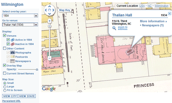
- At this point, you can dismiss the Thalian Hall pop-up, by selecting the [X] in the upper left corner of the information pop-up. The pink graphics indicate brick construction. The yellow graphics indicate a wood frame building. The map includes street names and street addresses. You will see that many of the buildings are also labeled with either business type or even proprietor's name. The maps also indicate under streets what type of water and gas mains exist.
- Using the "pan" feature, explore the buildings to the west (left) of the City Hall.
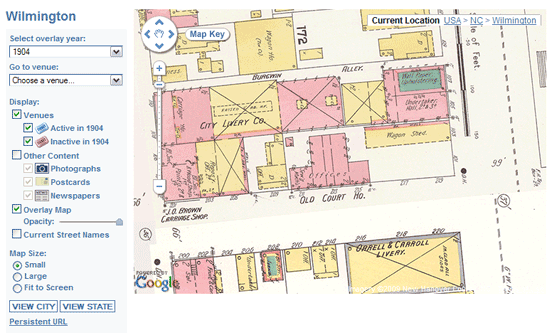
Ask the students to identify the buildings / businesses that support horse drawn carriage personal transportation. Examples include: the City Livery Col, the Orrell & Carroll Livery (note: Sanborn Maps indicate liveries with the X), so you see that there are a couple more liveries that are unlabelled. Have students record these businesses on the worksheet.
- 108-110 2nd Street at Burgwin Alley: City Livery and Carriage House
- 103 3rd Street: Wagon Shed
- north of Burgwin Alley between 2nd Street and 3rd Street: Wagon House
- 114 2nd Street: Harness
- 201 Princess: J.O. Brown Carriage Shop, Black Smith
- 216-220 Princess @ 3rd Street: Orrell & Carroll Livery
- 13-15 3rd Street: P.H. Haden Carriage & Harness Works
- 9 3rd Street: Black Smith
- 126-128 Princess / 23-27 2nd Street: J.D. Farrior, Livery
What percentage of the businesses in this view are related to the horse drawn carriage business?? Ask students why there might be such a high density of horse-based businesses at this location?? Might it be related to the proximity of the Wilmington City Hall?
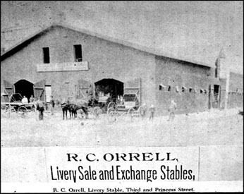
Photo of the R.C. Orrell Livery Sale and Exchange Stables - 3rd and Princess
http://wwwtmpapps.nhcgov.com/lib/history/fales/pages/slides/346.htm
You might want to "walk around" a few minutes to explore the various businesses that are illustrated in the map. "Walk" west (left) on Princess, until you reach Front Street, and then "walk" north (up) on Front Street. Front Street was a major commercial street for Wilmington. This takes you past the Orton Hotel, the U.S. Postal Office, and several theaters.
Return your view to the City Hall area, so that you can see the block directly to the west, as above. Using the "transparency" feature, reduce the opacity of the Sanborn Map to see what the present day buildings look like. Move the Overlay Map Opacity slowly to the left to reveal the underlying satellite image. Ask students to identify which buildings are still in place (e.g. the City Hall, the County Court Building), and what buildings have been replaced.
In a later activity, students will use the Select overly year: pulldown to look at this area and observe how the businesses have changed.
Activity 3: Exploring and Analyzing the 1907 Wilmington City Directory: 20-30 minutes (demonstration, as a class):
The next activity will explore another historical resource, the 1907 Wilmington City Directory. These are available on the Internet Archive website. The Wilmington City Directory was published by the Wilmington Chamber of Commerce, and is reasonably analogous to a telephone directory that provides listings of government, public and commercial businesses, and proprietors and residents. The Wilmington City Directory also denoted colored racial affiliations with an *.
Use this lesson as an introduction and orientation for the students to acquaint them with the Wilmington City Directories, the user interface features and navigation methods.
Provide students with the Evolution of Transportation Worksheet so that they can record their initial findings as you work through Activities 2 and 3. Explain that this worksheet will provide a summary of the horse-based and automobile-based businesses that you identify during your explorations.
For this lesson, you will focus on business categories related to the horse drawn carriage personal transportation industry
If students have individual computer access, have them follow along as you go through the following steps:
- Open a browser and go to the 1907 Wilmington City Directory website: http://www.archive.org/details/wilmingtonncdire1907hill
- Select the Read Online option from the View the book block.
- There are two major navigation options to introduce - page by page, or jump to a section:
- Page by page: Click on the right-facing page to advance forward a page, click on the left-facing page to advance backward a page.
Use the right arrow or left arrow found in the header space to advance page by page - Jump to a section: Click on a relative location of the vertical "stacked pages" to move to that "section" of the book
- Go to a specific page by entering the page number in the Page field found in the header Note: for navigating through the document, you may want to use the 2-page view. However, for clearer viewing of the text, you may want to toggle to the single-page view (button found to the right of the zoom options).
- Page by page: Click on the right-facing page to advance forward a page, click on the left-facing page to advance backward a page.
- Starting at the beginning of the city directory, click the right page 5 times to display the Facts about Wilmington, North Carolina in 1907. (Unfortunately, these pages are not numbered, but most of the directory does include page numbers) This provides a quick synopsis about Wilmington.
Consider the following questions as you look at these introductory statements about Wilmington:
- What is the Wilmington Chamber of Commerce's purpose in publishing this information?
- Who were the audiences for this publication?
- How might historians use this information?
- How should historians consider this information? e.g. how "authoritative" is this information?
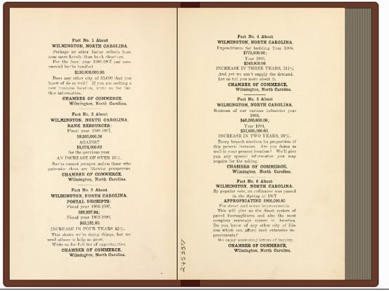
- Page forward one more page by clicking the right page 1 time to display the last page of Facts and the General Index. The General Index is very helpful and provides the general layout of the directory.
We're interested in the "categorical" business listings to explore the businesses related to the horse drawn carriage personal transportation industry. You will see that the "Business Directory" is listed on pages 383-447.
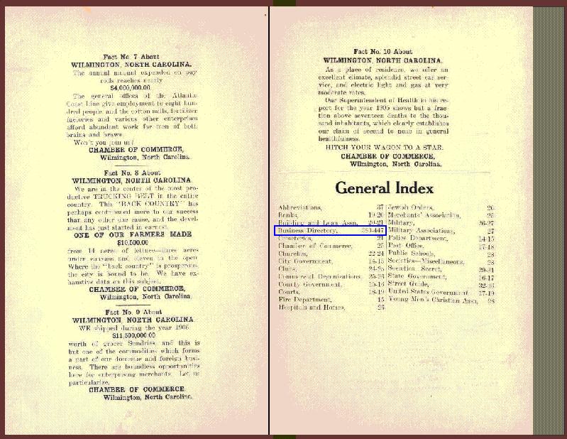
- Point your mouse about 90% through the vertical page leafs, and you should see a mouse-over hint that displays the page you're pointing at. You want to get near page 383. Page 383 provides the first page of a categorically organized listing. Page through the first few pages to explore the types of business categories, and start noting categories related to the horse-based transportation ... a few examples you might want to highlight:
Page 387: Blacksmiths and Wheelwrights - how many are there? what other services would these tradesmen provide?
Page 393: Carriage and Wagon Builders
Page 401: Drayage (notice the *s for many of the names) ... refer back to the City Hall photo for a photo of a Dray.
Page 415: Harness and Saddlery
Page 415: Hay, Grain and Feed
Page 416: Horseshoers
Page 424: Livery - Sales and Exchange Stables
Page 438: Saddlers
Page 438: Sales Stables
Page 385: Automobiles (for an early view of Automobile related businesses) - The directory also provides a standard alphabetized listing. Maybe you didn't notice, but the listings in the Business Directory section did not include phone numbers. Say, for example, that you had to visit the Wilmington City Hall, and that you wanted a place to leave your horse, and you wanted to call R.C. Orrell Livery. Go to page 268 of the city directory, and you will see the full entry for:
ORELL & ALEXANDER (Robert C Orrell, William F. Alexander), livery, transfer and boarding stable 3d cor Princess - phone 47
Activity 4: Analyzing the later images: 15 minutes (individually or in small groups):
Provide students with a photo-analysis worksheet, or a questionnaire you have developed that includes the basic questions you want to cover.
Have students take five minutes to look at the following photos, and ask them what aspects they note, from a transportation perspective. They can look at things like people, vehicles, road conditions, intersections. See if they can infer what time of year it is. What would have been the passenger experience in these vehicles have been like? How is parking handled? What types of dangers and hazards might be associated with this type of travel? Have them start thinking about consequential side-effects of this type of transportation (e.g. cleaning up horse manure in the city streets). Ask students questions about what types of supporting services and businesses would be built around this type of transportation.
Note: dates were not provided with many of these images. Ask students how they might go about determining date approximations.
Have them spontaneously jot down their impressions as they are viewing the photographs to capture their first impressions.
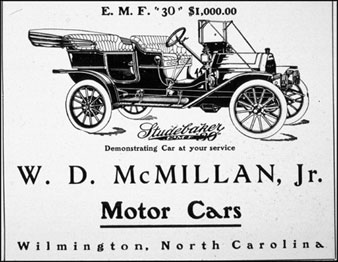
1911 E.M.F. Studebaker. Advertisement
http://wwwtmpapps.nhcgov.com/lib/history/fales/pages/slides/1144.htm
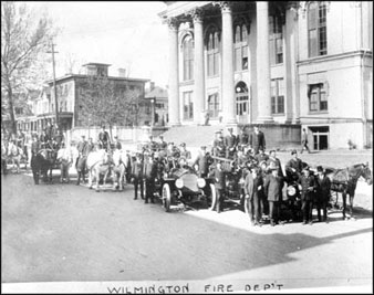
City Hall: 1917 - Wilmington Fire Department:
http://wwwtmpapps.nhcgov.com/lib/history/fales/pages/slides/9.htm
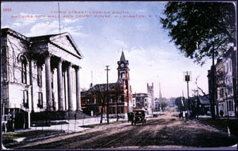
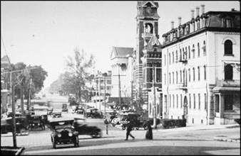
City Hall and County Courthouse: 3rd & Chestnut - looking south:
http://wwwtmpapps.nhcgov.com/lib/history/fales/pages/slides/597.htm
3rd and Market Streets, looking north on 3rd
http://wwwtmpapps.nhcgov.com/lib/history/fales/pages/slides/769.htm
Note: you can see the Colonial Inn (foreground on right), County Court House (tall tower on right), Wilmington City Hall (white building with peaked roof on right)
(1929) Second and Princess, looking east
http://wwwtmpapps.nhcgov.com/lib/history/fales/pages/slides/459.htm 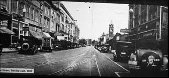
Activity 4b (Optional): Historical Detective Work: Dating pictures via elements in the photograph Most of the above photographs were not supplied with dates. However, students can attempt to date the pictures based on the automobiles in the pictures and using the chronological visual "catalog" of passenger vehicles in the National Museum of American History available from the Smithsonian's website: http://americanhistory.si.edu/onthemove/themes/story_78_3.html. By matching the automobiles found in the images with automobiles in the online catalog, students can estimate a date for the picture.
Introduction | Activity 1 -4 | Activity 5 - 7 | Worksheet (pdf) | Learn More