
Old State House, Indian Trading Path and Boone Trail Highway Marker (#5), Hillsborough
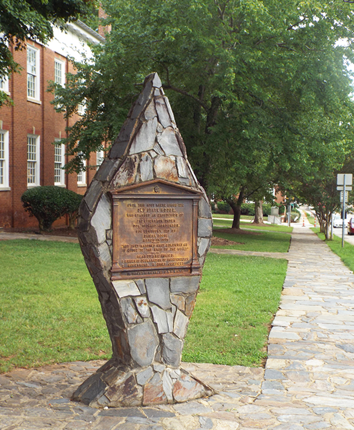
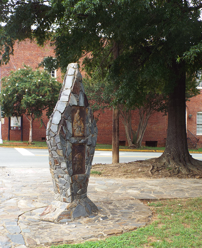
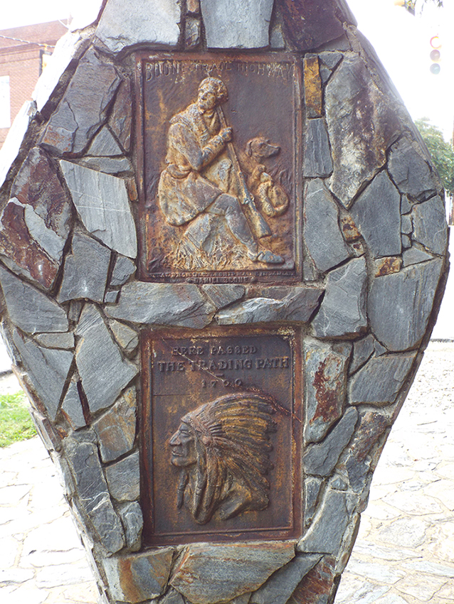
The monument is shaped in the form of an arrowhead, and the surface has been covered in a mosaic of natural field stones matching the stone sidewalk surrounding the site. One side bears an inscribed steel tablet in the shape of a classical Greek or Roman building; the other side bears two steel images, a relief image of Daniel Boone and his dog and a relief image of a Native American chief. The inscriptions on both sides of the monument indicate that metal in the plaques came from the U.S.S. Battleship Maine.
The Old State House tablet is the only one original to 1918. Its dedication was the one featured during a day of patriotic celebrations and a war bond drive. The Boone tablet was simply described as being placed above that of the Old State House tablet. News reports made no mention of the tablets being attached to an arrowhead.
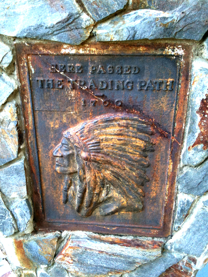
The Trading Path tablet was dedicated on July 4, 1931. The bas-relief Indian portrait was intended to represent “Chief Sequoia” (Sequoyah) of the Cherokee and shows an Indian wearing a feather headdress more indicative of plains Indians than the Cherokee. The Boone Highway tablet on the arrowhead is a style not seen until 1926 and probably replaced the one mentioned in 1918 news reports. That older tablet would have been a Style-1 that did not have the Boone Trail Highway caption along the top. The present Style-3 tablet is distinguished by having a slightly curved BOONE TRAIL HIGHWAY caption. It is assumed the arrowhead was constructed in 1931. As with many of the rock and masonry arrowheads that deteriorated over time this one has been rebuilt at least once.
This Boone Highway marker was numbered 5 by Everett G. Marshall. His interest and research of the markers led to the book, Rich Man, Daniel Boone. The numbering system was simply the order in which he found or became aware of a marker.
Images (courtesy of Rusty Long): Image of a Native American chief
|
Back view |
Old State House plaque |
Side view |
Two steel tablets on the back
North face (Old State House tablet): FROM THIS SPOT WHERE STOOD THE / OLD STATE HOUSE, / WAS AN EXPEDITION OF / FRONTIERSMAN UNDER / COL. RICHARD HENDERSON, / FOR KENTUCKY, LED BY / DANIEL BOONE / MARCH 17, 1776 / "AND THEY MARCHED AWAY SOLEMNLY AS / IF GOING TO THE ENDS OF THE WORLD" / NEAR BY ARE BURIED: / 1 SIGNER OF THE DECLARATION OF INDEPENDENCE / 2 GOVERNORS, 2 CHIEF JUSTICES / IN TABLET IS METAL OF U.S.S. MAINE
South face:
Inscribed above and below figure of Daniel Boone: BOONE TRAIL HIGHWAY / METAL FROM BATTLESHIP MAINE IN TABLET / DANIEL BOONE
Inscribed above the figure of a Native American Chief: HERE PASSED / THE TRADING PATH / 1700
Town of Hillsborough
Old Statehouse tablet: June 22, 1918. Boone and Indian Trail: July 4, 1931
36.075390 , -79.099400
View in Geobrowse
"J. Hampton Rich," from the "Images of North Carolina" digital collection, Davie County Public Library, (accessed January 21, 2015) Link
Jones, H.G. “Rich, Joseph Hampton,” NCPedia.org, (accessed March 22, 1917) Link
Jones, Randell. “Markers for Boone’s Trail Have Rich History,” Journal West (Winston-Salem, NC) November 26, 2013, (accessed March 13, 2017) Link
Marshall, Everett G. Rich Man: Daniel Boone (Dugspur, VA: Sugar Tree Enterprises, 2003)
Van Noppen, Ina W. 1979. "Boone, Daniel," NCpedia.org, (accessed January 10, 2014) Link
“Boone Expedition for Kentucky,” The Historical Marker Database, HMdb.org, (accessed June 5, 2017) Link
“Daniel Boone Trail Marker, Hillsborough, NC, Waymarking.com, (accessed June 5, 2017) Link
“Hillsboro to Hold All Day Celebration,” Durham Morning Herald (Durham, NC), June 12, 1918
“Hold Patriotic Meeting,” The Charlotte Observer (Charlotte, NC), June 22, 1918
Yes
Steel, stone and masonry
Old State House Tablet: Orange County War Savings Stamp Society and Boone Trail Highway and Memorial Association. Boone Trail Highway and Indian Trading Path: Boone Trail Highway and Memorial Association.
The 1918 dedication was held during a day of Patriotic and Historic meetings conducted under the auspices of the Orange County War Savings Stamp society and the Boone Trail Highway Association. A historical address was given by Frank Nash of Hillsborough.
During the 1931 dedication Boy Scouts marched from the school building to the marker carrying flags and singing patriotic songs. Hillsborough mayor T.M. Arrasmith presided and talks were given by J. Clyde Ray, Mrs. R.B. House, R.O. Everett, Mrs. Sidney Cooper and J. Hampton Rich.
J. Hampton Rich was a well-known figure in North Carolina’s “Good Roads Movement” during the early 20th Century when public pressure was used to force enhancements in the public highway system. Attaining minor celebrity status he eventually extended his vision beyond the borders of his home state. Using the legacy of Daniel Boone as a hook, he first began to cross North Carolina and then the United States drumming up support for commemorative highway markers. Between 1917 and 1938 Rich was one of the most prolific commemorators in the United States. He claimed responsibility for hundreds of markers, some in places that had no connection to Boone at all like Washington, D.C.; Boston, Massachusetts; Pike’s Peak, Colorado and at the Golden Gate Bridge in San Francisco.
Rich was born in 1874 on land where the family of Daniel Boone may have once lived. What is certain though is that Daniel Boone spent many of his 21 years in North Carolina living in the area near Mocksville in Davie County and surely Rich's lifelong passion for Boone was influenced by his immersion in local lore surrounding the famous frontiersman. Rich, who became a well-known newspaper man in Winston-Salem, also developed a passion for good highways in the state. Very likely taking a lead from a series of markers to Boone placed by the Daughters of the American Revolution beginning in 1912, Rich combined his two passions and came to the idea of capitalizing on the pioneer’s fame as a way to encourage the building of better roads.
In 1913, Rich established the Boone Trail Highway and Memorial Association with the chief purpose to raise awareness of the need for better roads in North Carolina. Rich also wanted to educate the public about the history and heritage of the pioneer era and promote patriotism. Beginning with the first documented marker, placed at East Bend in Yadkin County in 1917,
Rich claimed to have placed about 360 tablets across the United States by 1938. Of that number, (which came from Rich) less than 60 originals are still known to exist and it may be impossible to ever know how many were actually incorporated into a highway memorial. Although it is known that he sold some in the early years Riches method of operation was typically to give a tablet, sometimes multiple tablets, to a community with their promise to raise funds to erect the highway marker. In some cases it was years before a marker was ever constructed and it is almost certain that many markers were never completed. The number of markers with documented proof of being completed is less than 150. As more digitally preserved newspapers from the period become available this number will likely increase.
Each tablet with the image of Daniel Boone includes wording that it contains metal from the Battleship USS Maine sunk in Havana harbor in 1898 at the outset of the Spanish-American War. In 1916 with the help of then Secretary of the Navy, Josephus Daniels, Rich had acquired 300 pounds of metal salvaged from the ship. It is questionable that each plaque actually contained some of this metal. In a 1948 article from “The Daily Tar Heel” Rich is quoted as saying “the first tablets contained... metal from the battleship.” In addition to those featuring Daniel Boone, Rich also created tablets featuring “Cherokee Chief Sequoia” and a bison in an effort to mark ancient buffalo traces used by Native American and then Colonial settlers from the coast at Wilmington through the Great Smoky Mountains in the west. Very few of these were produced and few examples remain. Other efforts include tablets to Abraham Lincoln and possibly Davey Crockett. Regardless of the image on the tablet, these are lumped together under the heading of Boone Trail Highway and Memorial Association markers. The best current resource is Rich Man: Daniel Boone by Gary Marshall. His research efforts and the book’s publication in 2003 generated interest in finding and protecting the remaining markers.
Rich lived in Chapel Hill in the years prior to his death in 1949 where he could be seen “striding down the village streets wearing his coon skin cap and maybe with his long rifle thrown over one arm.” He was also "apt any day to walk into one of the University’s history classes clad in his furry cap, and always on these occasions he is introduced to the students by the professors as Daniel Boone."
The monument sits on the northwest corner of the green in front of the Old Courthouse square in Hillsborough at the intersection of South Churton Street and King Street. The inscribed side faces north and the intersection. The south side, with the images of Daniel Boone and the Native American Chief, faces the courthouse.
The monument sits at the edge of the grass in front of the courthouse where it meets the sidewalk. The sidewalk and the monument are both constructed in a mosaic of natural field stones. There are large old oaks shading the site.
 Know anything else about this monument that isn't mentioned here? If you have additional information on
this or any other monument in our collection fill out the form at the Contact Us link in the footer. Thank you.
Know anything else about this monument that isn't mentioned here? If you have additional information on
this or any other monument in our collection fill out the form at the Contact Us link in the footer. Thank you.


