
Boone Trail Highway Marker (#23), Churchland
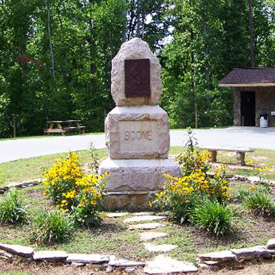
The Boone Trail Highway marker is comprised of three granite blocks on a base of concrete standing approximately 15 feet tall. Each piece has unfinished sides but the base and center plinth blocks have finished beveled edges. The plinth has a smooth recessed area on the front with BOONE incised in block letters. The upper section has the rough shape of an arrowhead with a blunt tip and holds a fiberglass reproduction of the Daniel Boone tablet placed by the Boone Trail Highway and Memorial Association. The reproduction is a Style-2 tablet that was first seen in 1919, used through 1926 and distinguished by the BOONE TRAIL HIGHWAY caption being in block letters. It holds an image in relief taken from Alonzo Chapel’s 1861 illustration of Daniel Boone and his hunting dog. This reproduction may be historically incorrect. By 1930 the Style-3 tablet would most likely have been used and is distinguished by the BOONE TRAIL HIGHWAY caption having larger letters and forming a slight curve across the top. The arrowhead top is also not original to the memorial as explained below.
The memorial began its life in 1910 as an arrowhead monument placed by the Daniel Boone Memorial Association. The base section held a plaque with Daniel Boone’s name and the years he lived in North Carolina. Three years later in 1913 the original plaque was replaced with one
sponsored by the Daughters of the American Revolution (DAR). This plaque marked the beginning of the Daniel Boone Trail and was one of 45 placed by the DAR in North Carolina, Tennessee, Virginia and Kentucky (see subject notes). By 1929 the monument and land which included Boones Cave (see subject notes) had been acquired by Joseph Hampton Rich, Managing Director of the Boone Trail Highway and Memorial Association. A news photo from 1929 shows Rich and the monument with the original arrowhead missing and the DAR plaque lying damaged to the side. Rich restored the monument by reattaching the DAR plaque and added the current arrowhead section with a Boone Trail Highway tablet. At some point both were stolen. The fiberglass Boone Highway replica was added after 2005.
This Boone Highway marker was numbered 23 by Everett G. Marshall. His interest and research of the markers led to the book, Rich Man: Daniel Boone. The numbering system was simply the order in which he found or became aware of a marker.
Images:
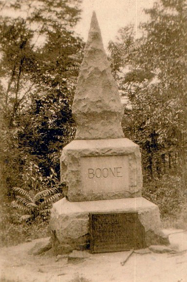
Memorial marker around 1913 (photo courtesy of Randell Jones)
Granite arrowhead: BOONE
1910 Plaque: Exact inscription not known but it contained the name of Daniel Boone and dates he lived in North Carolina
1913 Plaque: DANIEL BOONE’S TRAIL / FROM / NORTH CAROLINA TO KENTUCKY / 1769 / MARKED BY THE N.C. DAUGHTERS OF THE / AMERICAN REVOLUTION
1930 Reproduction tablet top: BOONE TRAIL HIGHWAY
Bottom: METAL FROM BATTLESHIP MAINE IN TABLET / DANIEL BOONE
Davidson County Parks and Recreation Department
April 30, 1910. November 1, 1913. Circa 1930
35.798050 , -80.466380
View in Geobrowse
Fesperman, Holly. “County Reviving Boone’s Cave Park,” Salisbury Post (Salisbury, NC), August 25, 2005
Jones Randell. “Markers for Boone’s Trail Have Rich History,” Winston-Salem Journal (Winston-Salem, NC), November 26, 2013, (accessed February 15, 2017) Link
Jones, H.G. “Rich, Joseph Hampton,” NCPedia.org, (accessed March 22, 1917) Link
Jones, Randell. Trailing Daniel Boone: Marking Daniel Boone’s Trail 1912-1915, (Winston-Salem, NC: Daniel Boone Footsteps, 2012)
Marshall, Everett G. Rich Man: Daniel Boone (Dugspur, VA: Sugar Tree Enterprises, 2003)
Stanford, Raney. “Shades of Dan’l Boone! Says J.H. Rich,” The Daily Tarheel (Chapel Hill, NC), February 8, 1948
Untitled, The Rowan Record, (China Grove, NC), April 22, 1910, 3
“Celebration in Boone,” The Dispatch (Lexington, NC), November 5, 1913
“Daniel Boone Marker #23, Boones Cave Park,” Waymarking.com, (accessed February 15, 2017) Link
“Daniel Boone Memorial Dedicated,” The Statesville Sentinel, (Statesville, NC), May 2, 1910, 1
“North Carolina Dedicated Monument to Daniel Boone.” The Los Angeles Times (Los Angeles, CA), May 1, 1910
“North Carolina Joins In Boone Trail Movement,” Asheville-Gazette News, (Asheville, NC), November 10, 1914, 3
“State Honors Daniel Boone,” Winston-Salem Journal (Winston-Salem, NC), May 1, 1910
“The Boone Tablet,” Winston Salem Journal (Winston-Salem, NC), May 17, 1916
“The Trail Taken by Boone Through State Now Marked,” News and Observer, (Raleigh, NC), July 11, 1915, 17
Yes
Bronze, Rowan County granite
1910 Arrowhead: Daniel Boone Memorial Association. Plaque: Daughters of the American Revolution. 1913 Plaque: General William Davidson Chapter Daughters of the American Revolution. 1930 Tablet: Boone Trail Highway and Memorial Association
In 1913 Boone’s Cave was considered to be in a remote location and the dedication was held one week later than originally planned because rain and mud made the site inaccessible. Some stretches of the road had “not been improved since Boone’s day.” Mrs. S.W. Finch made a speech of introduction on behalf of the William Davidson Chapter D.A.R. The plaque was presented to Mr. J. Ray McCrary president of the Daniel Boone Memorial Association for placement on the monument they had erected in 1910. Mrs. W.N. Reynolds, state regent of the D.A.R. and Mrs. Lindsay Patterson who chaired the trail committee also spoke. The unveiling was performed by four young children who removed the American flag that covered it.
The 1910 Arrowhead dedication was presided over by Governor W.W. Kitchen with the chief address delivered by Judge Jeter C. Pritchard before a crowd estimated at 10 to 15 thousand. The date was the 160th anniversary of the Boone family leaving Pennsylvania.
Daniel Boone’s trail as marked by the Daughters of the American Revolution (DAR) begins at Boone’s Cave Park, crosses the Yadkin River at the Shallow Ford near Huntsville, and ends at Fort Boonesborough, Kentucky where Boone served during the American Revolution. In 1913 DAR Chapters placed 13 markers along the North Carolina portion of the trail which mostly follows Old US Highway 421. Mrs. Lindsay Patterson of Winston-Salem chaired the project that eventually erected 45 tablets in North Carolina, Tennessee, Virginia and Kentucky along the route. At the Cumberland Gap (Tennessee) the four states combined to erect a single commemorative monument.
Boone’s Cave is tied to Daniel Boone by legend only. When he was sixteen he and his family settled in the Yadkin Valley of North Carolina. It was said they spent their first winter living in the cave before moving across the Yadkin River into what is now Davie County near Mocksville.
No verified historical evidence has ever been found that the Boone family lived in the cave or in Davidson County.
J. Hampton Rich was a well-known figure in North Carolina’s “Good Roads Movement” during the early 20th Century when public pressure was used to force enhancements in the public highway system. Attaining minor celebrity status he eventually extended his vision beyond the borders of his home state. Using the legacy of Daniel Boone as a hook, he first began to cross North Carolina and then the United States drumming up support for commemorative highway markers. Between 1917 and 1938 Rich was one of the most prolific commemorators in the United States. He claimed responsibility for hundreds of markers, some in places that had no connection to Boone at all like Washington, D.C.; Boston, Massachusetts; Pike’s Peak, Colorado and at the Golden Gate Bridge in San Francisco.
Rich was born in 1874 on land where the family of Daniel Boone may have once lived. What is certain though is that Daniel Boone spent many of his 21 years in North Carolina living in the area near Mocksville in Davie County and surely Riches’ lifelong passion for Boone was influenced by his immersion in local lore surrounding the famous frontiersman. Rich, who became a well-known newspaper man in Winston-Salem, also developed a passion for good highways in the state. Very likely taking a lead from a series of markers to Boone placed by the Daughters of the American Revolution beginning in 1912, Rich combined his two passions and came to the idea of capitalizing on the pioneer’s fame as a way to encourage the building of better roads.
In 1913 Rich established the Boone Trail Highway and Memorial Association with the chief purpose to raise awareness of the need for better roads in North Carolina. Rich also wanted to educate the public about the history and heritage of the pioneer era and promote patriotism. Beginning with the first documented marker, placed at East Bend in Yadkin County in 1917, Rich claimed to have placed about 360 tablets across the United States by 1938. Of that number, (which came from Rich) less than 60 originals are still known to exist and it may be impossible to ever know how many were actually incorporated into a highway memorial. Although it is known that he sold some in the early years Riches method of operation was typically to give a tablet, sometimes multiple tablets, to a community with their promise to raise funds to erect
the highway marker. In some cases it was years before a marker was ever constructed and it is almost certain that many markers were never completed. The number of markers with documented proof of being completed is less than 150. As more digitally preserved newspapers from the period become available this number will likely increase.
Each tablet with the image of Daniel Boone includes wording that it contains metal from the Battleship USS Maine sunk in Havana harbor in 1898 at the outset of the Spanish-American War. In 1916 with the help of then Secretary of the Navy, Josephus Daniels, Rich had acquired 300 pounds of metal salvaged from the ship. It is questionable that each plaque actually contained some of this metal. In a 1948 article from “The Daily Tar Heel” Rich is quoted as saying “the first tablets contained…metal from the battleship.” In addition to those featuring Daniel Boone, Rich also created tablets featuring “Cherokee Chief Sequoia” and a bison in an effort to mark ancient buffalo traces used by Native American and then Colonial settlers from the coast at Wilmington through the Great Smoky Mountains in the west. Very few of these were produced and few examples remain. Other efforts include tablets to Abraham Lincoln and possibly Davey Crockett. Regardless of the image on the tablet, these are lumped together under the heading of Boone Trail Highway and Memorial Association markers. The best current resource is Rich Man: Daniel Boone by Gary Marshall. His research efforts and the book’s publication in 2003 generated interest in finding and protecting the remaining markers.
Rich lived in Chapel Hill in the years prior to his death in 1949 where he could be seen “striding down the village streets wearing his coon skin cap and maybe with his long rifle thrown over one arm.” He was also “apt any day to walk into one of the University’s history classes clad in his furry cap, and always on these occasions he is introduced to the students by the professors as Daniel Boone.”
Boone Cave was designated a “state historic site” for many years. In the 1960’s when no historical evidence was found that the Boone family ever lived at Boone Cave, the historical site designation was removed which resulted in a court battle. As a result, North Carolina retained the site as a state park from 1971 until 2002. As the smallest park in the state system it was never assigned any staff and fell into disrepair and as noted the monument was vandalized for the second time in its history. The state planned to close the park but in 2003 agreed to let Davidson County assume it operation. Permanent staff and physical improvements to include hiking trails and picnic areas have since been added.
Boone’s Cave Park is located in the Churchland community southwest of Lexington. The address is 3552 Boones Cave Rd, Lexington, NC.
Boone’s Cave Park is a 110 acre county park overlooking the Yadkin River. The memorial marker stands on a green island in one of the rest stops along Boones Cave Road. It is surrounded by evergreen bushes.
 Know anything else about this monument that isn't mentioned here? If you have additional information on
this or any other monument in our collection fill out the form at the Contact Us link in the footer. Thank you.
Know anything else about this monument that isn't mentioned here? If you have additional information on
this or any other monument in our collection fill out the form at the Contact Us link in the footer. Thank you.


