About
| Collections
| Authors
| Titles
| Subjects
| Geographic
| K-12
| Facebook  | Buy DocSouth Books
Collections >> The First Century of the First State University >>
Primary document
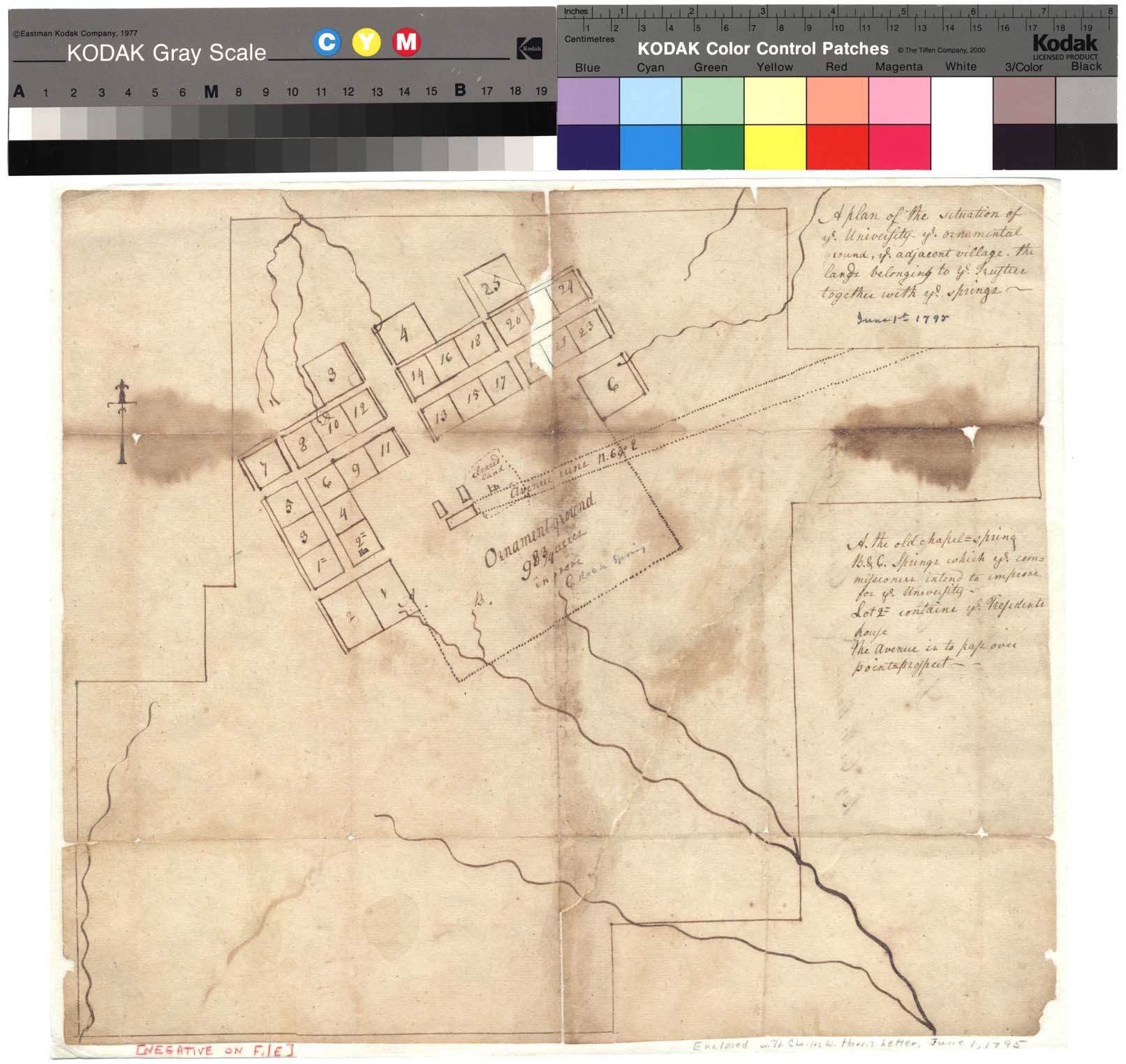
Title: A Plan of the Situation of ye University, ye Ornamental Ground, ye Adjacent Village, the Lands Belonging to ye Trustees Together With ye Springs, June 1, 1795: Electronic Edition.
Author: Harris, Charles Wilson, 1771-1804
Funding from the University Library, University of North Carolina at Chapel Hill supported the electronic publication of this title.
Text transcribed by
Bari Helms
Images scanned by
Imaging and Photographic Services, Wilson Library, University of North Carolina at Chapel Hill
Text encoded by
Brian Dietz
First Edition, 2005
Size of electronic edition: ca. 7K
Publisher: The University Library, University of North Carolina at Chapel Hill
Chapel Hill, North Carolina
2005

The electronic edition is a part of the University of North Carolina at Chapel
Hill digital library, Documenting the American South.
Languages used in the text:
English
Revision history:
2006-03-03, Brian Dietz finished TEI/XML encoding.
Source(s):
Title of collection: University of North Carolina Papers (#40005), University Archives, University of North Carolina at Chapel Hill
Title of document: A Plan of the Situation of ye University, ye Ornamental Ground, ye Adjacent Village, the Lands Belonging to ye Trustees Together With ye Springs, June 1, 1795
Author: [C. W. Harris]
Description: 1 page, 1 page image
Note:
Call number 40005 (University Archives, University of North Carolina at Chapel Hill)
oclc:
27188892
Editorial practices
The text has been encoded using the recommendations for Level 5 of the TEI in Libraries Guidelines.
Originals are in the University Archives, University of North Carolina at Chapel Hill.
Original grammar, punctuation, and spelling have been preserved.
Page images can be viewed and compared in parallel with the text.
Any hyphens occurring in line breaks have been removed, and the trailing part of a word has been joined to the preceding line.
All quotation marks, em dashes and ampersand have been transcribed as entity references.
All double right and left quotation marks are encoded as ".
All single right and left quotation marks are encoded as '.
All em dashes are encoded as —.
Indentation in lines has not been preserved.
For more information about transcription and other editorial decisions, see the section Editorial Practices.
A Plan of the Situation of ye University, ye Ornamental Ground, ye Adjacent Village, the Lands Belonging to ye Trustees Together With ye Springs, June 1, 1795
Page 1