
Driving Through Time - The Digital Blue Ridge Parkway

Search Results:
-
 Bridge
September 18, year unknown
-
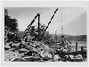
 Building the end wall
1930s
-
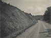
 Road construction
1930s
-
 Stone Masons
1935
-
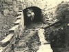
 Special Headwall, 10' x 7' R.C. Box
May 25, 1935
-
 Special headwall 10' x 7' R.C. box
May 25, 1935
-
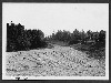
 Before grading. Gullies in fill. Soil erosive. Needs flattening.
July 25, 1935
-
 Before grading. Showing objectionable effect of uniform slopes and insufficient rounding
July 25, 1935
-
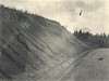 Before grading. Gullies and cave-ins. Slope too steep.
July 25, 1935
-
 Before grading. Washout ditch filled; needs transition, rounding, and drainage structure.
July 25, 1935
Items in Query
Results: 268
Refine Your Search
Types (3)
Photographs (265) Newspaper Articles (2) Maps (1)Locations (38)
Section 2A (69) Section 2C (39) Doughton Park (16) Milepost 238 (13) Milepost 225 (12) Cumberland Knob (9) Brinegar Cabin (8) Milepost 224 (8) Air Bellows Gap (7) Milepost 226 (7) Milepost 227 (7) Milepost 217 (6) Milepost 229 (6) Milepost 228 (5) Milepost 230 (5) Bluff Park (4) Bluffs (4) Milepost 221 (4) Milepost 247 (4) Alleghany County (3) Milepost 218 (3) Milepost 222 (3) Milepost 241 (3) Devil's Garden (2) Hare Mill Pond (2) Intersection of Blue Ridge Parkway and North Carolina State Route 18 (near Laurel Springs, N.C.) (2) Junction of 2A/2B (2) Milepost 223 (2) Milepost 239 (2) Milepost 240 (2) Pine Creek Bridge #4 (2) Bluff Park Maintenance Area (1) Bluffs Lodge (1) Milepost 219 (1) Milepost 242 (1) Milepost 244 (1) R.L. Martin Tract (1) Section 2B (1)Sections (3)
2A (149) 2C (101) 2B (16)Counties (1)
Alleghany (268)

