
Driving Through Time - The Digital Blue Ridge Parkway

Search Results:
-
Land Acquisition Maps Section 2-D
1940
-
 Northwest Trading Post
1940s
-
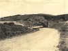 Bridge Structure
1940
-
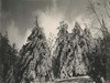
 White pine covered with ice
March 14, 1940
-
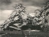
 White pine covered with ice
March 14, 1940
-
 White pine covered with ice
March 14, 1940
-
 White Pine Covered with Ice
March 14, 1940
-
 Burnt car found on Sec 2E
July 19, 1940
-
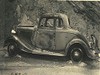
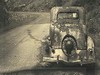 Burnt car found on Sec 2E. Full report by Ranger Coombs
July 19, 1940
-
 Soil Erosion
1941
Items in Query
Results: 50
Refine Your Search
Types (2)
Photographs (47) Maps (3)Locations (14)
Milepost 251 (13) Milepost 268 (8) Section 2D (7) Section 2E (7) Laurel Fork Viaduct (2) Milepost 248 (2) Milepost 257 (2) Milepost 261 (2) Milepost 263 (2) Daniels Gap (1) Milepost 250 (1) Milepost 252 (1) Milepost 260 (1) Northwest Trading Post (1)Sections (2)
2D (32) 2E (18)Counties (1)
Ashe (50)

