
Driving Through Time - The Digital Blue Ridge Parkway

Search Results:
-
 Overpass location at Benge (back)
June 19, 1935
-
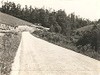
 Big Fill to Right of Picture
June 19, 1935
-
 Dry Masonry Fireplace
June 19, 1935
-
 Dry Masonry Fireplace
June 19, 1935
-
 Mountain Laurel
June 20, 1935
-
 Overpass near Mulberry Gap (from NC #18 on west)
June 20, 1935
-
 Overpass (NC #18) near Mulberry Gap Back
June 20, 1935
-
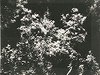 Flame Azalea
June 21, 1935
-
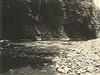 Cliffs along Linville River 1,000 Feet Upstream from Bridge
August 1, 1935
-
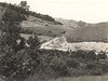
 General View from NC Route 26
August 15, 1935
Items in Query
Results: 158
Refine Your Search
Types (1)
Photographs (158)Locations (63)
Laurel Fork Viaduct (17) Milepost 242 (14) Bear Den Campground (5) Milepost 255 (5) Milepost 270 (5) Milepost 271 (5) Milepost 319 (5) Milepost 261 (4) Milepost 262 (4) Milepost 266 (4) Milepost 276 (4) Milepost 317 (4) Milepost 322 (4) Intersection of Blue Ridge Parkway and North Carolina State Route 18 (near Laurel Springs, N.C.) (3) Milepost 233 (3) Milepost 247 (3) Milepost 250 (3) Milepost 263 (3) Milepost 267 (3) Air Bellows Gap (2) Buck Creek Gap (2) Doughton Park (2) Milepost 229 (2) Milepost 231 (2) Milepost 240 (2) Milepost 251 (2) Milepost 252 (2) Milepost 272 (2) Milepost 274 (2) Milepost 323 (2) Milepost 324 (2) Milepost 325 (2) Section 2E (2) Section 2J (2) Sheets Gap Overlook (2) Boone (N.C.) (1) Daniels Gap (1) Devil's Garden (1) E.B. Jeffress Park (1) Gillespie Gap (1) Little Switzerland (1) Mahogany Rock (1) McKinney Gap (1) Milepost 234 (1) Milepost 241 (1) Milepost 248 (1) Milepost 256 (1) Milepost 257 (1) Milepost 258 (1) Milepost 259 (1) Milepost 264 (1) Milepost 265 (1) Milepost 268 (1) Milepost 273 (1) Milepost 279 (1) Milepost 309 (1) Milepost 353 (1) Roaring Gap (1) Section 2A (1) Section 2D (1) Section 2H (1) Section 2K (1) Twin Tunnel #2 (1)Sections (12)
2D (41) 2E (40) 2C (25) 2K (22) 2B (10) 2J (7) 2A (4) 2M (3) 2F (2) 2L (2) 2H (1) 2N (1)Counties (8)
Ashe (52) Alleghany (39) Wilkes (23) McDowell (16) Avery (13) Watauga (8) Mitchell (5) Yancey (2)

