
Driving Through Time - The Digital Blue Ridge Parkway

Search Results:
-
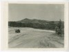 View of Tuggles Gap crossing of parkway with Virginia Route No. 8
July 1936
-
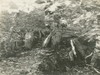
 Edward's store
July 1936
-
 Rocky Knob Park
August 1936
-
 Looking south at concessions area
August 1936
-
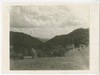
 View south-west toward Mason's Knob from proposed center line of Parkway
August 1936
-
 View from proposed center line of Parkway between Mason's Knob and Buck Mtn.
August 1936
-
 View toward Roanoke from point in proposed centerline of Parkway between Lynchburg Road and Coyner's Mountain
August 1936
-
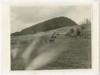
 View of trail over Rocky Knob
August 1936
-
 View toward Coyner's Mtn. from a point proposed centerline of Parkway
August 1936
-
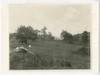
 View from proposed lodge site
August 1936
Items in Query
Results: 60
Refine Your Search
Types (1)
Photographs (60)Locations (18)
Milepost 168 (22) Milepost 165 (11) Milepost 170 (4) Sharp Top Mountain (Va.) (4) Milepost 107 (2) Milepost 120 (2) Milepost 121 (2) Milepost 126 (2) Rocky Knob (Va.) (2) Milepost 144 (1) Milepost 155 (1) Milepost 167 (1) Milepost 169 (1) Milepost 60 (1) Milepost 98 (1) Peaks of Otter (1) Roanoke, Va. (1) Smart View (V.A.) (1)Sections (8)
1S (30) 1R (11) 1K (6) 1M (6) 1N (2) 1Q (2) 1G (1) 1P (1)Counties (7)
Floyd (26) Patrick (15) Roanoke (7) Bedford (6) Franklin (3) Botetourt (2) Amherst (1)

