
Driving Through Time - The Digital Blue Ridge Parkway

Search Results:
-
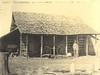 Front of barn as it would be seen from the parkway.
April 21, 1938
-
 Looking West from One of the Parking Areas South of Cumberland Knob
April 27, 1938
-
 Shelter on Top of Cumberland Knob
April 27, 1938
-
 Big Cut at Devil's Garden
June 14, 1938
-
 60ft cut at Devils Garden
June 14, 1938
-
 Signs near parking area
July 1, 1938
-
 Water Fountain
July 1938
-
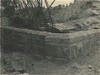 West Abutment, Overpass US 21
July 12, 1938
-
 Unpaved roadway with erosion
July 25, 1938
-
 Before grading. Cleared to connect slope line, with rock as excuse for steep slope. Ugly profile.
July 25, 1938
Items in Query
Results: 33
Refine Your Search
Types (3)
Photographs (30) Drawings, Plans, and Projections (2) Maps (1)Locations (12)
Section 2A (9) Cumberland Knob (5) Devil's Garden (4) Milepost 224 (4) R.L. Martin Tract (3) Milepost 219 (2) Cumberland Knob Park (1) Hare Mill Pond (1) Milepost 218 (1) Milepost 223 (1) Milepost 228 (1) Milepost 229 (1)Sections (1)
2A (33)Counties (2)
Alleghany (32) Surry (1)

