
Driving Through Time - The Digital Blue Ridge Parkway

Search Results:
-
Land Acquisition Maps Section 2-K
1939
-
Fire Hazard Map
1939
-
Detail Map of Location from the Blue Ridge Parkway to Mt. Mitchell, under County Project 595, Buncombe, Yancey Counties
1940
-
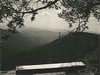 Overlook in Bluff area looking south
1940
-
Geologic Maps, Part of the Master Plan for the Blue Ridge Parkway
1940
-
 Parkway Crossings of Major Highways (Page 1 of 2)
January 31, 1940
-
 Parkway Crossings of Major Highways (Page 2 of 2)
February 2, 1940
-
Land Acquisition Maps Section 2-F
1941
-
Qualla and 3200 Acre Tracts, Cherokee Indian Reservation, North Carolina
1937
-
 Stable - Two Horses, Construction Details
January 1942
Items in Query
Results: 52
Refine Your Search
Types (3)
Maps (39) Photographs (10) Drawings, Plans, and Projections (3)Locations (31)
Bluff Park (7) Cumberland Knob (4) Section 2G (4) Section 2A (3) Section 2B (2) Section 2N (2) Section 2R (2) Bluff Park Maintenance Area (1) Bluffs (1) Cumberland Knob Park (1) Doughton Park (1) Laurel Springs (1) Milepost 238 (1) Milepost 239 (1) Milepost 254 (1) Mount Mitchell (1) NC State Line (1) Section 2F (1) Section 2J (1) Section 2K (1) Section 2L (1) Section 2M (1) Section 2P (1) Section 2Q (1) Section 2U (1) Section 2W (1) Section 2X (1) Section 2Y (1) Section 2Z (1) Undetermined (1) Virginia State Line (1)Sections (20)
2C (12) 2A (9) 2G (4) 2N (3) 2B (2) 2D (2) 2R (2) 1W (1) 2F (1) 2J (1) 2K (1) 2L (1) 2M (1) 2P (1) 2Q (1) 2U (1) 2W (1) 2X (1) 2Y (1) 2Z (1)Counties (14)
Alleghany (22) Watauga (5) Buncombe (4) Yancey (4) Jackson (2) McDowell (2) Ashe (1) Avery (1) Cherokee (1) Grayson (1) Haywood (1) Surry (1) Transylvania (1) Wilkes (1)

