
Driving Through Time - The Digital Blue Ridge Parkway

Search Results:
-
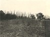 Picnic area before clearing operations
April 21, 1936
-
 Picnic area before clearing
April 21, 1936
-
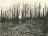
 Cumberland Knob Picnic Area
April 28, 1936
-
 Cumberland Knob Picnic Area
April 28, 1936
-
 Switchback on trail from Cumberland Knob, picnic area to gulley. Creek showing ramps.
May 30, 1936
-
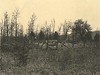
 View within lower or wooded picnic area
August 1936
-
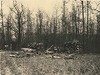
 View within lower or wooded picnic area
August 1936
-
 View within wooded or lower picnic area
August 1936
-
 View within upper picnic area
August 1936
-
 Looking toward upper picnic area and Rocky Knob
August 1936
Items in Query
Results: 127
Refine Your Search
Types (3)
Photographs (121) Drawings, Plans, and Projections (4) Newspaper Articles (2)Locations (27)
Doughton Park (28) Cumberland Knob (15) Milepost 168 (14) Cumberland Knob Park (13) Peaks of Otter Picnic Area (12) Craggy Picnic Area (6) Crabtree Meadows (5) Rocky Knob (Va.) (5) Bluffs (3) Bluff Park (2) Milepost 217 (2) Milepost 241 (2) Section 1D (2) Craggy Gardens (1) Folk Art Center (1) Milepost 218 (1) Milepost 238 (1) Milepost 240 (1) Oteen (1) Peaks of Otter (1) Pine Spur Park (1) Ravens Roost Overlook (1) Section 1S (1) Smart View (V.A.) (1) Soco Gap (1) Undetermined (1) Wildcat Rocks Overlook (1)Sections (12)
2C (38) 2A (31) 1S (20) 1K (13) 2P (7) 2M (5) 1D (2) 2Q (2) 1C (1) 1P (1) 1Q (1) 2Y (1)Counties (11)
Alleghany (56) Floyd (14) Bedford (13) Surry (13) Buncombe (9) Patrick (6) McDowell (5) Franklin (2) Nelson (2) Augusta (1) Haywood (1)

