
Driving Through Time - The Digital Blue Ridge Parkway

Search Results:
-
 View of road
1930s
-
 Layout plan Picnic Shelter
1930s
-
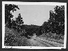
 View of road
1930s
-
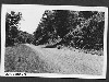
 View of road
1930s
-
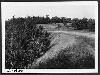
 View of road
1930s
-
 Station 566
1930s
-
 School Near Head of Glade Creek
1930s
-
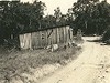
 Cumberland Knob Park Entrance
1930s
-
 Farmland and road
1930s
-
 View of road
1930s
Items in Query
Results: 652
Refine Your Search
Types (5)
Photographs (638) Maps (8) Drawings, Plans, and Projections (3) Newspaper Articles (2) Oral Histories (1)Locations (25)
Section 2A (191) Cumberland Knob (110) Milepost 229 (39) Milepost 217 (35) Milepost 224 (33) Milepost 225 (32) Cumberland Knob Park (31) Milepost 221 (23) Milepost 227 (20) Milepost 218 (19) Milepost 228 (19) Fox Hunters Paradise (17) Milepost 226 (13) Milepost 222 (11) Hare Mill Pond (10) Devil's Garden (9) Milepost 220 (8) Milepost 223 (7) Milepost 219 (6) Pine Creek Bridge #4 (6) Fishers Peak (3) Intersection of Blue Ridge Parkway at North Carolina State Route 18 (near Ennice, N.C.) (3) R.L. Martin Tract (3) Glade Valley (2) NC State Line (2)Sections (1)
2A (652)Counties (2)
Alleghany (621) Surry (31)

