
Driving Through Time - The Digital Blue Ridge Parkway

Search Results:
-
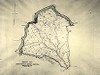 Typical Sheet Property Map
20th Century
-
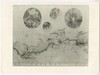 Photograph of Master Plan - Buena Vista to Laurel Fork
November 6, 1936
-
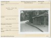
 Cumberland Knob
June 1946
-
 Parkway Map and Layman's Herbarium Cabinet
June 1956
-
 Illuminated Map in N.W. Trading Post
July 1958
-
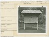 Rocky Knob Campground Sign
August 21, 1962
-
 North Carolina Minerals - Location Map
August 1965
-
 Visitors at Information Counter (Saul Schiffman)
August 1965
-
 Register - Rocky Knob Campground
June 1971
-
 Register - Rocky Knob Campground
June 1971
Items in Query
Results: 21
Refine Your Search
Types (1)
Photographs (21)Locations (13)
Rocky Knob (Va.) (4) Craggy Gardens Visitor Center (3) Asheville (2) Museum of North Carolina Minerals (2) Bluffs (1) Cumberland Knob (1) Laurel Springs (1) Milepost 2 (1) Milepost 60 (1) Peaks of Otter (1) Peaks of Otter Campground (1) Peaks of Otter Picnic Area (1) Section 2J (1)Sections (11)
1S (4) 1K (3) 2P (3) 2L (2) 2R (2) 1B (1) 1G (1) 2A (1) 2C (1) 2D (1) 2J (1)Counties (9)
Buncombe (5) Patrick (4) Bedford (3) Alleghany (2) Mitchell (2) Amherst (1) Ashe (1) Avery (1) Nelson (1)

