
Driving Through Time - The Digital Blue Ridge Parkway

Search Results:
-
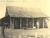 Front of barn as it would be seen from the parkway.
April 21, 1938
-
 Barn proposed for acquisition. Note logs and shake roof.
April 21, 1938
-
General Development Plan, Peaks of Otter Park, 6/8/1939
1939
-
Land Acquisition Map, Pine Spur Park, 10/31/39, revised Jan 18, 1962
1939
-
Negro Area Development, Pine Spur Park, 10/4/1940
1940
-
Geologic Maps, Part of the Master Plan for the Blue Ridge Parkway
1940
-
Topography-Negro Area, Pine Spur, 2/17/1940
1940
-
 Parkway Crossings of Major Highways (Page 1 of 2)
January 31, 1940
-
 Parkway Crossings of Major Highways (Page 2 of 2)
February 2, 1940
-
Property Map & List of Owners, Peaks of Otter, 19 March 1941, rev 6/13/1941
1941
Items in Query
Results: 69
Refine Your Search
Types (5)
Maps (30) Photographs (20) Newspaper Articles (15) Drawings, Plans, and Projections (2) Oral Histories (2)Locations (20)
Humpback Rocks Visitor Center and Mountain Farm (11) Section 1P (5) Asheville (3) Section 1C (3) Brevard (2) Grandfather Mountain (2) R.L. Martin Tract (2) Section 1B (2) Section 1S (2) Craggy Gardens (1) Milepost 5 (1) Milepost 50 (1) Milepost 60 (1) NC State Line (1) Rocky Knob (Va.) (1) Section 1J (1) Section 1Q (1) Smart View (V.A.) (1) Soco Gap (1) Williamsburg (Va.) (1)Sections (13)
1B (14) 1P (5) 1C (3) 1S (3) 2A (3) 2R (3) 1G (2) 1Q (2) 2H (2) 2V (2) 1J (1) 2P (1) 2Y (1)Counties (13)
Augusta (16) Buncombe (4) Alleghany (3) Patrick (3) Avery (2) Transylvania (2) Amherst (1) Bedford (1) Floyd (1) Franklin (1) Haywood (1) Nelson (1) Rockbridge (1)

